
| Head : Prof. Yuei-An Liou |
|---|
Center for Space and Remote Sensing Research, National Central University |
|---|
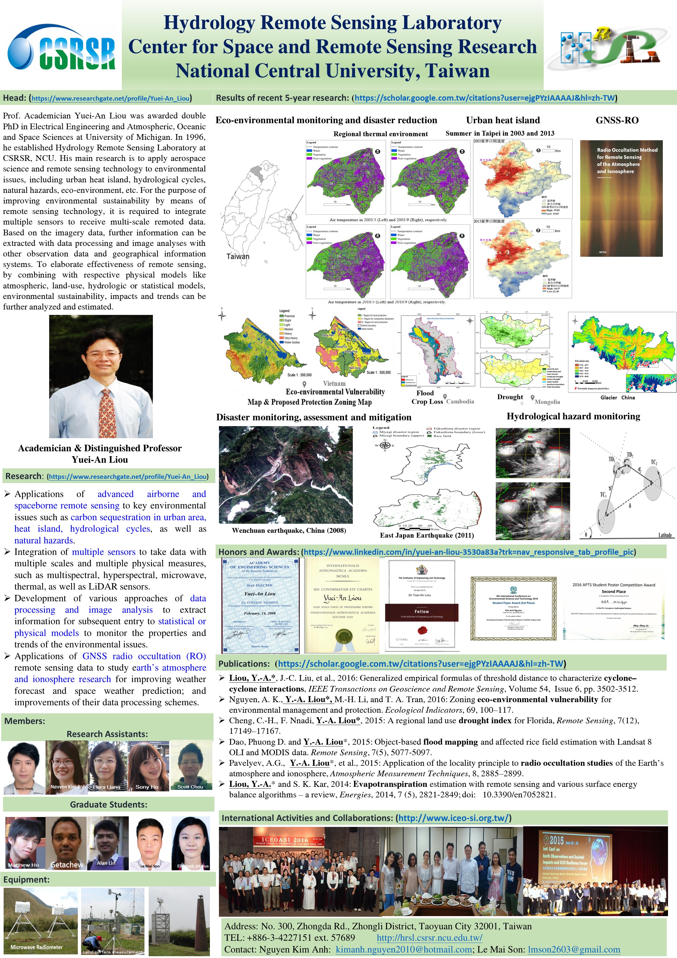
My recent research interests include the applications of advanced airborne and spaceborne remote sensing to key environmental issues such as carbon sequestration in urban area, heat island, hydrological cycles, as well as natural hazards. For these purposes, it is required to have an integration of multiple sensors to take data with multiple scales and multiple physical measures, such as multispectral, hyperspectral, microwave, thermal, as well as LiDAR sensors. This requires handling of geospatial information by geographical information systems. Various approaches of data processing and image analysis are then adopted to extract information for subsequent entry to statistical or physical models to monitor the properties and trends of the environmental issues. Remote sensing technologies are new enabling technologies which enable us to care for our living environment to achieve the sustainability. |
|---|
Hydrology Remote Sensing Laboratory (HRSL) has been continuously thriving and developing based on the solid support from Ministry of Science and Technology, National Applied Research Laboratory (National Space Organization), Dept. of Land Administration (Ministry of Interior), Water Resources Agency (Ministry of Economic Affairs), Civil Aeronautics Administration (Ministry of Transportation and Communications), Ministry of Education, Academia Sinica, Office of Naval Research (USA), and National Science Foundation and other units. |
|---|
The observation platform includes the satellites and ground-based sensors. Spaceborne sensors such as FORMOSAT3/COSMIC, FORMOSAT2, SPOT, MODIS, LANDSAT, AMSR, ALOS, etc.; ground observation instruments such as the Global Positioning System (GPS), Microwave Radiometer, Multiband / Hyperspectral Sensor, LiDAR , etc. |
|---|
This project proposal is based on a policy of the Executive Yuan “A government to interact well with people”. It applies three guiding principles of Premier Mao: “communicated concepts”, “implemented actions” and “advanced administrations”. Generally speaking, the project aims to build up a platform to “integrate and determine information on disaster prevention and response”, and to “analyze and react on public opinions”, by means of open data, big data and crowdsourcing. Its objective is to optimize government’s administration and create the two-way communication, in order to strengthen the efficiency of disaster reaction. The platform is to apply earth observation data and image analysis technique to determine and demonstrate the disaster conditions, to integrate the information on disaster sites and relevant losses provided by the public, and to actively explore the social networking and media information. It will assist relevant disaster prevention and decision-making authorities to proceed with the mitigation of disaster damages. Through this technique of analyzing the public opinions and social-media networks, it facilitates further communications between the disaster prevention authorities and the public and distinguishes disaster-area social communities from professional ones, in order to make the public accept government’s information easily. It can also integrate the rescue capacity of local social communities, fully elaborate functions of earth observation data and space information, strengthen current compound disaster-response capacity, and protect the safety of human life and property to achieve the administrative objective of “people to feel happiness due to the government’s administration”. |
|---|
Land surface process (LSP) parameterization plays an essential role in the construction of the numerical weather model and global circulation model. However, the key issues associated with energy balance of land surface process – a one-spot or one-site measurement cannot be used to describe the characteristics of spatial distributions with complex terrain. Then, one question surfaces, how can pointwise measurements be used to describe the surface characteristics of the other non-measureable sites? Hence, this project is designed to be implemented in three years with goals to answer the said question. The long-term observations include data from our ASOS (Automated Surface Observing System) sites and HiWATER (Heihe Watershed Allied Telemetry Experimental Research) project. Both adopt Bowen ratio and Eddy covariance systems (BRS and ECS) with the doubt that energy balance cannot be closed and thus it is crucial to solve the problem of unbalance energy budget by observational networks. Based on long-term observation of large-scale areas with different natural conditions, the objectives of this project are (i) Upgrading the current equipment of our ASOS to enhance the accuracy and reliability of the measured parameters of the land surface processes, (ii) Reducing the problem of unbalance energy budget at the land-air interface, and (iii) Contributing to the improvements of parameterizing the comprehensive theory for different regions. The first-year (2015/8-2016/7) plan is currently being implemented. The equipments of our ASOS were continuously maintained and upgraded to enhance capacity of completed long-term BRS and ECS observation. The sites form an observation network system to collect parameters of land surface process from Chiayi city and Heihe watershed, and the accuracy and quality of data were assessed. In the second year, girds method proposed by Cressman will be used to estimate the parameters of land surface process. These parameters will be compared with and refined based on sub-telemetry data, and characteristics of factors in the two areas will be evaluated. In the third year, the performance of the proposed method for ungauged sites will be evaluated, and the statistical properties will be characterized. Parameters will be established to be applicable with different natural conditions, and to analyze the characteristics of factors, which affect the land surface process between two regions. The driving forces of energy balance of land surface process such as regional difference will be discussed in great detail. |
Taoyuan’s Land Use and Land Cover (LULC) has rapidly changed in recent decades (e.g. urban expansion and vanishing of farmland and ponds, etc.). These changes have subsequently impacted the regional environment. This study incorporates the space science and technology with the remote sensing technology; as the continuation of the previous project titled: "Using remote sensing data to analyze Taoyuan farm ponds change impacts on regional thermal environment (1/2) (NSC 102-2221-E-008-034)". The strategy management technology from the Earth Observation Systems was adopted by coupling the Data mining and the Kriging interpolation method to simulate effects of different feature changes on the regional thermal environment. Analysis model is also to be verified with the remote sensing data or ground truth data. We aim to improve the decision-making capability with the assistance of spatial data analysis and Geographic Information Systems. Research on farm ponds change impact to the regional environment development is also to be conducted in order to explore the value of ponds from the area sustainability perspective. The index of importance level of farm ponds in the area can be served as a basis for county agency’s decision making on pond reservation policies. |
The LULC changes in the Taoyuan area have obviously and strongly affected the number of farmland and ponds. Therefore, in this study, we combine statistical analysis and remote sensing technology, with aims at exploring the impact of LULC changes (ponds and farmland) on the regional environment in Taoyuan through the use of satellite observation data. By taking the multi-periods (1993, 2003 and 2010) of SPOT images, they were classified into three types as water body (ponds), vegetation area (farmland) and non-vegetation area (buildings and bare land) with the unsupervised classification (ISODATA) method and the accuracy assessment (error matrix and kappa statistic index). Due to the fact that the error matrix and kappa statistic index are greater than 90 % and 0.8, respectively, it is shown that the results of image classification are of a high degree of reliability in the three images to explicate the changing relationship among LCLU and to quantify the whole area of the ponds changes, and then to assess the effect of different changes of LULC on regional environment. We found, while non-vegetation area is increased by 110 % between 1993 and 2010 in the study area, the water body is reduced by 10.55 million m2 and the vegetation area by 162.34 million m2. Furthermore, it is obtained 6.2 percent of buildings and bare land comes from the ponds and 93.8 percent comes from the farmland in the 18 years of concern. In this way, it can explain urban development or implementation of the policy has caused the LULC changes. However, the LULC changes have impacted the regional issues of natural environment and economic environment in the period of concern in Taoyuan, and they may further modify the regional temperature variation in thermal environment, as well as possible effect on humanities and social environment. We will investigate these issues in the second year. |
Land surface process parameterization plays a very important role in the numerical weather model and global circulation model through quantifying the exchange of energy and water between the land and the air. Its observation is used to support the claim of global warming for the mainstream meteorologists on the one hand; on the other hand, its unreliability is accused by those people who suspect global warming. Therefore, this continuing project is planned to be a three-year term. We will apply measurements from four evapotranspiration measurement systems set up since 2005 and existing ground observation stations to investigate the unreliability, parameterization, and optimization of land surface processes in order to improve the parameterization, theory and techniques of observation of the land surface processes. By now, we have completed the first-year plan with aim to enhance the stability of observation stations, targeting at comprehensive analysis on observations of existing stations, upgrading, maintaining and testing operations of its software and hardware, including analyzing past five-year and current observing data, "Sustainable power supply system," "Observation and Recording System" and "Remote Data Transmission System", to become an automated surface observing system (ASOS). The second-year plan is being conducted to enhance the accuracy of observation stations. The observation stations currently adopt the Bowen ratio and eddy covariance systems with the doubt that energy balance cannot be closed (Rn + G0 / H + LH ≠ 1). We will parameterize the energy exchange process between the land surface and the lower atmosphere, with the surface energy balance of the original treatment (Rn = G0 + H + LH) to set up the correction operation of the parameterization, in order to improve the problem of unbalance energy budget at the land-air interface to obtain more accurate measurements from ground observation stations and to describe the characteristics of surface fluxes. For the time being, we are proposing the third-year plan to enhance the reliability of comprehensive observation network. We will establish the station network among different land type terrains to execute the regional parameterization calculation based on the point of view of land surface observation and sub-telemetry data interpretation. We will then compare, analyze, and correct algorithm parameterizations and reduce the observation inaccuracy caused by the change of surface process. |
This project was cooperated by the following units: National Science Council, Ministry of Economic Affairs, and Academia Sinica. Partners inculdes: Director Lin, Chuan-Yao (Academia Sinica), Dr. Liu Zhi-Zhong (Industrial Technology Research Institute), Researcher Dr. Liu, Jin-King, and Researcher Dr. Xiao Guo-Xin. The project aims to establish the Monitoring Technology on the intensity of the current urban heat island effect, by deploying the satellite remote sensing thermal imagery , high spatial resolution airborne thermal infrared sensors, ground weather stations, and WRF / Noah / UCM modes, in the wide, regional , micro- regional scale, separately. And monitoring the selected areas to understand the hot urban areas (hot spots) distributions. The results for this research will lay the foundation to establish the database of the urban heat island effect. And the value-added applications of the urban heat island effect. Subsequent benefits can be expanded further to build a nation-wide database of urban heat island effect, and for the countermeasures and suggestions for the industrial technology development in the heat island areas. |
The study on the hydrologic cycle and energy exchange between the Earth's surface and atmosphere has been one of important research issues in global change and environmental monitoring and disaster mitigation in Taiwan. In the past, much effort has been made on the design and implementation of the sensors and sensing systems. The measurement results provide much information, so the development of the corresponding theoretical models can be more complete. While there is mainly image information in optical remote sensing, microwave remote sensing, which uses sensing system in microwave frequency range, is able to provide more physical information. The physical information retrieved from the microwave system can be applied to improve the models and the physics of atmospheric and hydrologic cycle. In this project, we will perform a feasibility study of a 5-frequancy, dual-polarized scanning microwave radiometer for the study of the Earth's atmosphere and oceans. The tentative chosen frequencies are 10.7, 18.7, 23.8, 36.5 and 89.0 GHz to cover most of the atmospheric and oceanic applications. We will analysis the pros and cons of different designs of the proposed microwave radiometer and recommend the most affordable designs to NSPO. In the future, the proposed microwave radiometer will be built if the budget is available. |
SuomiNet”, a university-based, real-time, national Global Positioning System (GPS) network, is being developed for atmospheric research and education with funding from the National Science Foundation (NSF) and with cost share from collaborating universities. The network, named to honor meteorological satellite pioneer Verner Suomi, will exploit the recently-shown ability of ground-based GPS receivers to make thousands of accurate upper and lower atmospheric measurements per day. Phase delays induced in GPS signals by the ionosphere and neutral atmosphere can be measured with high precision simultaneously along a dozen or so GPS ray paths in the field of view. These delays can be converted into integrated water vapor (if surface pressure data or estimates are available) and total electron content (TEC), along each GPS ray path. The resulting continuous, accurate, all-weather, real-time GPS moisture data will help advance university research in mesoscale modeling and data assimilation, severe weather, precipitation, cloud dynamics, regional climate and hydrology. Similarly, continuous, accurate, all-weather, real-time TEC data have applications in modeling and prediction of severe terrestrial and space weather, detection and forecasting of low latitude ionospheric scintillation activity and geomagnetic storm effects at ionospheric mid-latitudes, and detection of ionospheric effects induced by a variety of geophysical events. SuomiNet data also have potential applications in coastal meteorology, providing ground truth for satellite radiometry, and detection of scintillation associated with atmospheric turbulence in the lower troposphere. The goal of SuomiNet is to make large amounts of spatially and temporally dense GPS-sensed atmospheric data widely available in real-time, for academic research and education. (Adopted from Ware et al., 2000, Bulletin of the American Meteorological Society) |
FORMOSAT3 was successfully scheduled on April 15, 2006. It consists of six low earth orbit (LEO) satellites at height near 800 km. The six LEO satellites form a Constellation Observing System for Meteorology, Ionosphere and Climate (COSMIC). Its scientific goal is to utilize the radio occultation (RO) signals to measure the bending angles when the GPS signals transect the atmosphere. The bending angle is then used to infer atmospheric parameters, including refractivity, temperature, pressure, and relative humidity fields of global distributions through inversion schemes and auxiliary information. The number of RO events is around 2500 per day, of which 200 events or so fall into the polar region. Consequently, the FORMOSAT3 observations are expected to play a key role in the weather forecasting and space physics research. In this proposal, it is our intention to extend the use of the FORMOSAT3 data to study atmospheric activities in the polar region, which, through atmospheric activities of particle precipitation, joule heating, and wave dynamics, influences the weather at lower latitudes, essentially climate change. |
The project is intended to use the L-band radiometer for scientific applications. From the findings given in literature, it is evident that the L-band radiometer is a useful and effective tool to measure soil moisture. Therefore, L-band is the only choice by past satellite mission proposals and ongoing satellite mission to measure soil moisture. For example, NASA plans to implement SMAP (Soil Moisture Active-Passive mission) mission to measure surface soil moisture and surface freeze/thaw state from satellite L-band radar and L-band radiometer in the 2010-2013 timeframe. Furthermore, the ESA-sponsored SMOS (Soil Moisture and Ocean Salinity) mission is expected to be launched next year (2009). The proposed instrument is based on a L-band interferometric radiometer (passive microwave, 1.4GHz) with an average spatial resolution of 43 km (30 to 50 km depending on the view angle) and a repetition of 3 days at the equator (only ascending orbits) (http://www.cesbio.ups-tlse.fr/us/indexsmos.html). The SMOS mission will measure global soil moisture and ocean salinity. The objective of this project is to develop and to verify the soil moisture retrieval algorithms for the L-band radiometer system. Through the radiometer-observed brightness temperature, surface emissivity and reflectivity can be derived, and, hence, soil moisture. Since there are no related field campaigns in Taiwan, we will collect field data from overseas experiments at the early stage to assist the development of the retrieval algorithm. The developed algorithms will be tested against our own data and improved for practical use. |
The Global Positioning System (GPS) has been applied in a wide range of applications in Taiwan, which may be divided into two major categories based on the platform of the receivers, namely ground-based and space-borne approaches. Satellite tracking stations are unmanned, all-weathered and 24 hours operative signal receiving stations. The information received at these stations is so voluminous that the coordinate of each tracking station itself, after numerous repeated computations is very precisely positioned and can serve as the bases for satellite control point surveying. |
The positioning accuracy achieved with the Global Positioning System (GPS) has been continuously improved during the last two decades. Historically, the main error sources, which have significantly been reduced or eliminated, were ionospheric refraction, orbital error, antenna phase center variation, signal multipath and scattering by the environment nearby the receiver, and tropospheric refraction. For GPS static and kinematic positioning, its accuracy has been significantly improved over the past few years with the advanced technology. Since the typical practice of GPS positioning ignores the natural inhomogeneity of atmospheric water vapor, high precision positioning is limited, especially in its vertical component. The first step to reduce, if not eliminate, the influence of the presence of tropospheric delay shall be understood and modeled. In this proposal, we intend to investigate the impact of tropospheric delay on the GPS post-kinematic positioning determination. The impact will be examined quantitatively using data acquired from permanent GPS stations along with meteorological measurements. Computations based on independent baseline as well as networking will be simultaneously investigated and analyzed. It is expected the accuracy of GPS post-kinematic positioning determination will be increased especially in the vertical component. |
It is a typical practice to use the meteorological satellite derived cloud-base temperature, its gradient, and growth rate along with the ground radar and rain-guage measurements of rainfall to perform quantitative prediction forecasts (QPF), while the total precipitable water (TPW) that is of ultimate source of rainfall is generally not taken into account. It is hence crucial to utilize the TPW as auxiliary information to improve the rainfall estimate, and to be used for consequent applications in water resources management and flash flood prevention. The satellite data to be utilized will include GMS (visible, infrared, and water vapor channel), GPS data, or others that may be applied. This study consists of three major parts: (1) Collect meteorological satellite data, and establish the technique of estimating TPW and rainfall from meteorological satellite or other satellite data, and establish the technique of estimating TPW using GPS, and examine the relationship between TPW and rainfall rate. (2) Develop the rainfall estimate scheme by incorporating the measured TPW as a constraint from meteorological satellite or others; investigate the potential use of GPS-derived TPW in short-term QPF. (3) Further validate and advance the developed rainfall estimate schemes. |
Since the MicroLab-1 was launched in 1995, there have been many studies showing the reliability of the radio occultation soundings of the Earth's atmosphere. The issues of major concerns are in how accurate the observation may be achieved and how much value of the radio occultation data may be extended. Overall speaking, the error sources of the retrievals from radio occultation data come from either instruments or the environment where the radio waves propagate through due to the assumptions of a stratified atmosphere, circular Earth volume, or horizontally-homogeneous water vapor distribution causing diffraction and mutipath effects. Consequently, the improved treatments to the way how radio waves propagate through the atmosphere between the transmitter and receiver are of great concern in recent years and near future. In the past, we have devoted to study the scheme for correcting ionospheric influence, and to examine the impacts of the diffraction and super-refraction. In addition, our efforts are directed to develop the radio holographic and full spectrum retrieval schemes, which are capable of resolving the influence of multipath and the problem of mathematical singularity, while some difficulties remain to conquer. The retrievals before assumed the structure of atmosphere is multi-layer spherical symmetrical. Unfortunately, the structure of atmosphere is not as perfect as that. Under some perturbations, like gravity wave, the distribution of atmosphere is not continuous. It may make the refraction angle to raise suddenly when signal goes through the discontinuous area and produces multipath situation at lower troposphere. In future, we will consider the variation of RO signal when propagate through the discontinuous atmosphere under the effect of gravity wave, and improve the retrieval program, which will allow us conveniently to simulate multipath and find the features of Doppler spectrum. In addition, we will use Kirchhoff's diffraction theory to consider the effects of diffraction of RO signal. Finally, we will explain the multipath of RO signal at lower troposphere. |
It is our key goal to obtain a better scientific understanding of how to define the nature and role of remotely sensed land surface parameters and energy fluxes in heat island phenomena, local and regional weather and climate, and air quality characteristics. In the timeframe of this proposal, three primary objectives are to be accomplished: to develop and improve the schemes of estimating surface parameters and fluxes through remotely sensed data including tower-based, airborne, and spaceborne visible and thermal imagery data; to monitor the urban growth, to classify land cover change, and to investigate the development of the urban heat island phenomenon through time at the region of study by using remotely sensed data; to investigate and model the relationship between heat island effect and surface energy budget characteristics. The scientific approach involves analyzing combinations of remotely sensed observations and in situ meteorological measurements to derive the surface parameters and fluxes of interest. The typical processes to derive the parameters and fluxes include data acquisition, radiometric correction, geometric correction, landuse classification, estimate of surface temperature and leaf area index (LAI), albedo and Normalized Difference Vegetation Index (NDVI) retrievals, and treatment of surface energy budget equations through certain simplifying boundary assumptions (Liou et al. 2002). Subsequently, urban growth and land cover change over time may be presented. Their relationship to the surface energy budget characteristics can be investigated. |
「GPS Science and Application Research Center, GPSARC」is the center which NSPO and NCU set up together. |
Rice is one of the major staple foods and paddy rice field accounts for approximately 15% of arable land (IRRI, 1993) in the world. Hence, estimating spatial distribution and rice yields of the paddy is important for governmental food management. In addition, a unique physical feature of paddy rice is characterized by an initial period of flooding and transplanting (Xiao et al., 2005), which is also an important subject. In tradition, the method of investigation spatial distribution of the paddy area is to apply aerial photography interpretation, it is of high accuracy but needs a lot of manpower and time to obtain information. In recent years, remote sensing technology is becoming mature, and then the application of the spectral characteristics of remote sensing images can effectively interpret the spatial distribution of paddy rice fields. In this study, in order to retrieve wide range of surface features in the same period and estimated rice yields in Chiayi region, we use MODIS satellite images and ground truth data to identify paddy area and estimate rice yields. |
Under the aegis of many relative organization with support, the Hydrology Remote Sensing Lab. is growing up strong and sturdy. In a broader perspective, we will use the energy accumulated in the past, upgrade continually and fulfill the developing theories and technologies on the practical operations for the sake of human well-being. |
|---|
 |
|---|